Locals flee to shelter, as Melissa intensifies to Category 2 hurricane
Article By: Old Harbour News

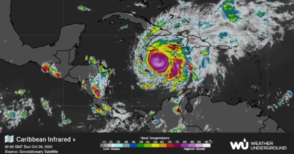
An infrared image of the Caribbean Sea provided by the Geostationary Satellite shows the current status of Category 2 Hurricane Melissa as at 9:00 PM Jamaica Time on Thursday, October 25, 2025.
Chairman of the disaster committee at the St Catherine Municipal Corporation, Dr Kurt Waul, says majority of those persons now at Old Harbour High – one of several facilities being used as a shelter - are residents who live along the Old Harbour Bay shoreline.
Dr Waul, who is also councillor of the Old Harbour South Division, said Old Harbour High is the only active shelter in the constituency at the moment, with persons from as far as Spring Village utilizing the facility.
“The other shelters are not being operationalized as yet, as persons haven’t seen the need to move into them as yet,” he said providing an update. “In Old Harbour Bay a lot of the persons who live along the seaside have taken it upon themselves to move into the shelter at Old Harbour High without. This is commendable and so we urge other persons who will be affected to move now before its too late.
“We anticipate more persons to move into the shelters once the storm gets closer or makes landfall, but for now some are playing a wait-and-see game before making any definitive decision.
“So far today we have been using a JUTC bus to transport persons to the shelter. This will be the case throughout going forward.”
Meanwhile, the United States-based National Hurricane Center (NHC) issued a grave warning Saturday evening as Hurricane Melissa embarked on a period of rapid intensification, placing Jamaica in the crosshairs of a potentially catastrophic Category 5 storm early next week.
According to the latest NHC discussion, Melissa is showing all the signs of a rapidly strengthening hurricane currently at Category 2 strength. Satellite imagery reveals a storm organizing with alarming speed, featuring extremely cold cloud tops and a well-defined eye approximately 20 nautical miles wide. Data from reconnaissance aircraft and advanced microwave sensors indicate that rapid intensification — a process where a hurricane’s winds increase dramatically in a short period — is already underway.
“There is a very serious situation developing,” the NHC bulletin stated, urging residents in warning areas to rush all preparations to completion.
The forecast track calls for Melissa to continue moving slowly westward over the next 24-48 hours, steered by a ridge of high pressure to its north. This path is expected to bring the powerful core of the hurricane dangerously close to Jamaica by early Tuesday. Thereafter, the storm is predicted to turn abruptly northward, moving over eastern Cuba by early Wednesday.
The intensity forecast is what has forecasters most concerned. The NHC now predicts Melissa’s winds will peak at 140 knots (approximately 161 mph) in 48 hours, solidifying it as a high-end Category 5 hurricane. This aggressive forecast is supported by multiple state-of-the-art models, including the Google DeepMind ensemble, where a majority of scenarios predict Category 5 strength.
“It is worth stressing that there is very little practical difference in the overall impacts of a Category 4 or 5 landfall,” the NHC emphasized, indicating that Melissa is expected to be at least a Category 4 hurricane when it reaches Jamaica.


