Why slow-moving hurricanes like Melissa cause most devastation
Article By: Old Harbour News

These lingering tempests are nature’s version of water torture, trading a single, brutal blow for a prolonged, unbearable pressure that can break a region's back. The recent behavior of Hurricane Melissa in the Atlantic serves as a textbook example of this very principle, demonstrating how a powerful storm can become exponentially more dangerous when it stalls.
A hurricane is a massive engine designed to wring moisture from the atmosphere and dump it on the land. When such a system stalls or crawls at just a few miles per hour, the same communities remain trapped beneath its swirling bands for hours, or even days, on end.
The result is rainfall measured in feet, not inches. Consider these real-world examples:
- Hurricane Harvey (2017): The benchmark for this phenomenon. After making landfall in Texas, Harvey stalled, its movement grinding to a near standstill. For five days, it pulled trillions of gallons of water from the Gulf of Mexico and dumped them on Houston and surrounding areas. Some locations received over 60 inches of rain — the highest tropical cyclone rainfall total ever recorded in the United States. The resulting floods were catastrophic, inundating entire neighborhoods, crippling a major American city, and causing $125 billion in damage.
- Hurricane Florence (2018): Similarly, Florence slowed to a crawl before hitting the Carolinas, deluging the region with widespread rainfall of 20-35 inches. This transformed gentle coastal rivers into raging torrents that swallowed towns miles inland, proving that a hurricane’s water footprint can be far more vast than its wind field.
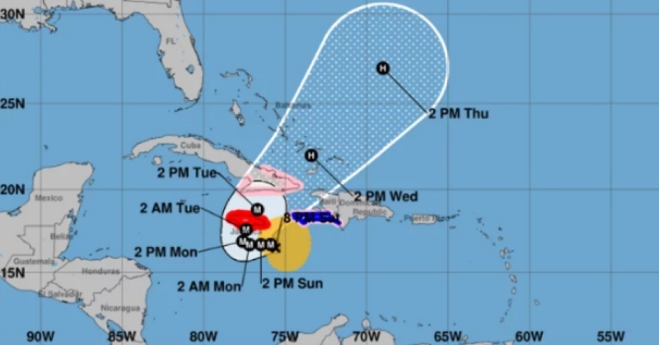
As a current reference, Hurricane Melissa exemplifies this threat over the open ocean.
Despite Melissa’s rapid intensification, it has been making a slow crawl not exceeding 5 mph. This stalling behavior is a perfect demonstration of the mechanics that lead to catastrophic rainfall, resulting in unprecedented accumulations, precisely mirroring the dangerous patterns of Harvey and Florence.
Weather experts are forecasting unprecedented rainfall that will overwhelm drainage systems, and causes rivers and streams to swell far beyond their banks, leading to catastrophic inland flooding that can strangle communities far from the coast.
The storm surge — the dome of seawater pushed ashore by a hurricane's winds — is typically the most deadly aspect of these storms. A slow-moving hurricane exacerbates this threat significantly. Instead of a surge that rolls in and out with the tide, a lingering storm can subject the coastline to an elevated surge for multiple tidal cycles.
Floodwaters are not just deep; they are persistent. They have more time to seep into structures, weaken foundations, and prevent emergency crews from conducting rescues.
The constant, punishing wave action against seawalls, dunes, and buildings over many hours leads to catastrophic erosion and structural failure that a faster-moving storm might not cause.
Beyond the physical damage, the slow pace of these storms inflicts a unique psychological burden. For residents, the experience transforms from a frantic, hours-long ordeal into a days-long siege. The constant howl of wind, the incessant drumming of rain, and the terrifying, incremental rise of floodwaters create an atmosphere of helplessness and anxiety.
Furthermore, the prolonged nature of the event strains emergency services to their absolute limits. Rescue crews become exhausted, resources are depleted, and the window for safe evacuation or assistance narrows and sometimes closes entirely. The recovery process is also lengthened, as the scale of the flooding damage is often more complex and widespread to repair than wind damage.
Alarmingly, there is growing scientific evidence that climate change may be making these slow-moving hurricanes more common. A warming atmosphere affects global wind patterns, potentially weakening the steering currents that typically propel hurricanes across the ocean. Research suggests that the forward speed of tropical cyclones has slowed globally, giving these storms more time to unleash their fury in one location. The stalling of Hurricane Melissa over the Atlantic, while a natural occurrence in its specific context, is an atmospheric behavior consistent with the broader, observed trend of slowing tropical systems.
While it is natural to focus on a hurricane’s category — a measure solely of its wind speed — this can be a dangerous oversimplification. The most dangerous storm is not always the one with the highest wind speed, but the one that refuses to leave. A slow-moving hurricane, with its endless rain, persistent storm surge, and agonizing duration, possesses a unique capacity for destruction. Hurricane Melissa, even out at sea, provides a clear and current case study in how a powerful storm's trajectory can be just as critical as its intensity. It teaches a brutal lesson: in the face of a stalled storm, time itself becomes the enemy, and water becomes the ultimate weapon. When the next hurricane approaches, pay close attention not just to its strength, but to its speed — because a meandering storm is often a catastrophe in slow motion.
“We have to bear in mind also that with the slow movement of the system it doesn’t allow you to recover… It’s going to sit there pouring water while its barely moving; and that’s a significant challenge that we need to be aware of. It’s going to cause significant, widespread, catastrophic, life-threatening floods,” said Evan Thompson, chief meteorologist at the Jamaica’s Met Service during an emergency press conference this morning.


